Cartography: Intersections and Sites of Interest

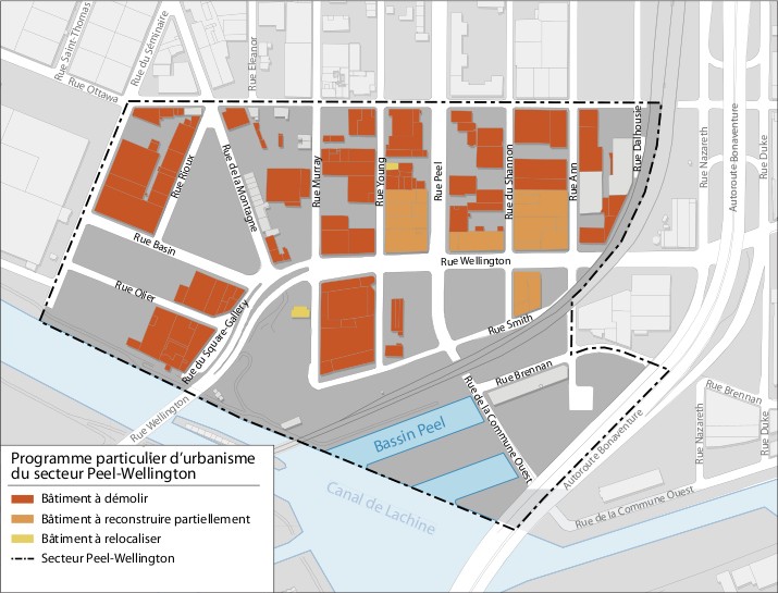
This project aims to take a snapshot in time of the area of Griffintown affected by the Programme particulier d'urbanisme du secteur Peel-Wellington. This is achieved through digital photography with text notes. It is currently possible to view every intersection in the sector from eight cardinal points.
Demolition/Reconstruction/Relocalisation Map taken from the Programme particulier d'urbanisme du secteur Peel-Wellington (Annexe F) on March 15th, 2008 (Source: Ville de Montréal - Arrondissement Sud-Ouest)
Intersections (click for photos) Sites of Interest (click for photos)
01:   Dalhousie + Ottawa 01:   New City Gas Company
02:   Ann + Ottawa 02:   Former Police Station Number 07
03:   Shannon + Ottawa 03:   John Moore House
04:   Peel + Ottawa 04:   Martin-Riley House / Leo's Horse Palace
05:   Young + Ottawa 05:   Former Oka Sand and Gravel
06:   Murray + Ottawa 06:   St-Ann's Park
07:   Eleanor + Ottawa 07:   Mountain Street Row Houses
08:   de la Montagne + Ottawa 08:   Mountain Temple Place
09:   du Séminaire + Ottawa 09:   La Cache / April Cornell
10:   du Séminaire + Basin 10:   View From Wellington Bridge
11:   du Séminaire + Olier    
12:   Square Gallery + Olier    
13:   Lachine Canal near Wellington    
14:   Rioux + Basin    
15:   de la Montagne + Wellington    
16:   Murray + Wellington    
17:   Young + Wellington    
18:   Peel + Wellington    
19:   Shannon + Wellington    
20:   Ann + Wellington    
21:   Ann + Smith    
22:   Shannon + Smith    
23:   Peel + Smith    
24:   Young + Smith    
25:   Murray + Smith    
26:   CN Bridge @ Peel Basin    
27:   de la Commune + Brennan    
28:   Ann + Brennan    
29:   de la Commune @ Autoroute Bonaventure    
30:   Lachine Canal Park @ Autoroute Bonaventure    
 
Griffintown, about a century ago...
This photo is taken from a series of posters of the former Montréal waterfront located under the Bonaventure Expressway on Rue de la Commune.

Return